Alaska is divided into 30 boroughs and census areas, each serving as a regional division for local administration. Unlike most U.S. states, Alaska does not have counties. Instead, it uses a combination of organized boroughs (with local government) and unorganized boroughs (managed directly by the state).
There are 19 organised boroughs and 1 unorganised borough divided into 11 Census Areas.
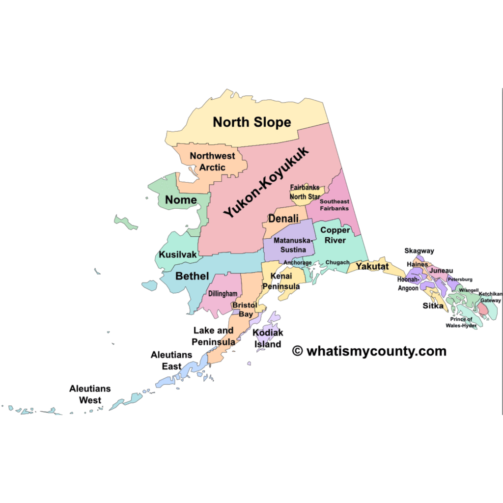
Interactive Map of All Alaska Boroughs & Census Areas
Click on any area below to explore more about it.
Interactive Map of All Alaska Counties
Click on any county below to explore more about it.
| No. | Borough/Census Area | Largest Community | Map & ZIP Code |
|---|---|---|---|
| 1 | Anchorage Municipality | Anchorage | Anchorage Map Link |
| 2 | Matanuska-Susitna Borough | Wasilla | Matanuska-Susitna Map Link |
| 3 | Fairbanks North Star Borough | Fairbanks | Fairbanks North Star Map Link |
| 4 | Kenai Peninsula Borough | Kenai | Kenai Peninsula Map Link |
| 5 | Juneau City and Borough | Juneau | Juneau Map Link |
| 6 | Bethel Census Area | Bethel | Bethel Map Link |
| 7 | Ketchikan Gateway Borough | Ketchikan | Ketchikan Gateway Map Link |
| 8 | Kodiak Island Borough | Kodiak | Kodiak Island Map Link |
| 9 | North Slope Borough | Utqiaġvik | North Slope Map Link |
| 10 | Nome Census Area | Nome | Nome Map Link |
| 11 | Sitka City and Borough | Sitka | Sitka Map Link |
| 12 | Kusilvak Census Area | Hooper Bay | Kusilvak Map Link |
| 13 | Northwest Arctic Borough | Kotzebue | Northwest Arctic Map Link |
| 14 | Southeast Fairbanks Census Area | Delta Junction | Southeast Fairbanks Map Link |
| 15 | Chugach Census Area | Valdez | Chugach Map Link |
| 16 | Prince of Wales-Hyder Census Area | Craig | Prince of Wales-Hyder Map Link |
| 17 | Aleutians West Census Area | Unalaska | Aleutians West Map Link |
| 18 | Yukon-Koyukuk Census Area | Galena | Yukon-Koyukuk Map Link |
| 19 | Dillingham Census Area | Dillingham | Dillingham Map Link |
| 20 | Aleutians East Borough | Sand Point | Aleutians East Map Link |
| 21 | Petersburg Borough | Petersburg | Petersburg Map Link |
| 22 | Copper River Census Area | Glennallen | Copper River Map Link |
| 23 | Hoonah-Angoon Census Area | Hoonah | Hoonah-Angoon Map Link |
| 24 | Haines Borough | Haines | Haines Map Link |
| 25 | Wrangell City and Borough | Wrangell | Wrangell Map Link |
| 26 | Denali Borough | Healy | Denali Map Link |
| 27 | Lake and Peninsula Borough | King Salmon | Lake and Peninsula Map Link |
| 28 | Skagway Municipality | Skagway | Skagway Map Link |
| 29 | Bristol Bay Borough | Naknek | Bristol Bay Map Link |
| 30 | Yakutat City and Borough | Yakutat | Yakutat Map Link |
Alaska Borough/Census Map Download
You can download the Borough map from below: